NORWAY COUNTIES
- Territory Guide
- NORWAY COUNTIES
Transform your map of Norway counties into an analytics powerhouse that fuels unstoppable business growth! Think of it as your supercharged tool for strategic planning—perfect for brands aiming to expand their reach seamlessly across regions. With this map’s detailed insights, you can spot emerging patterns that give you a competitive edge, assess risks to make confident decisions and uncover hidden opportunities that drive impactful results.
Don’t let valuable insights go unnoticed—harness the power of a Norway county map today to chart a clear path to success and dominate your market!
WHAT ARE NORWAY COUNTIES?
Norway, a stunning Nordic country in Northern Europe, is known for its breathtaking fjords and progressive governance. As a unitary state, it is divided into 15 first-level administrative regions called counties. These counties are overseen by directly elected county councils, which appoint a County Mayor to lead their efforts. They play a crucial role in regional governance, balancing local autonomy with national policy, and ensuring efficient administration across Norway’s diverse and sprawling landscapes.
In 2017, the Norwegian government initiated reforms to streamline administration by merging some smaller counties into larger ones. As of January 1, 2024, this reorganization has resulted in the current structure of 15 counties, which remain the cornerstone of Norway’s first-level administrative divisions.
Let’s set up this territory map for you in under a minute to start your country-level mapping!
ADD NORWAY COUNTIES
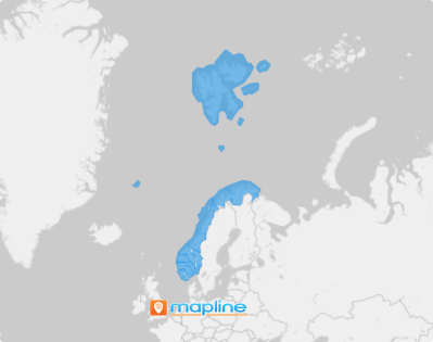
Add county boundaries to your map for a more detailed visualization that can help you make informed decisions when you see connections between your data and county territory.
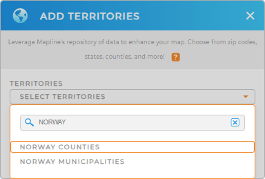
If you have 60 seconds or less, then let’s go ahead and add a new territory from Mapline’s repository. Type NORWAY in the search bar and choose NORWAY COUNTIES.
That’s how simple Step 1 is. Let’s turn you over quickly to Step 2.


Pro Tip: Get access to Mapline’s global territory repository to add Norway territories including Norway municipalities and counties to your map in seconds! Every level is a new vantage point—revealing patterns, sparking breakthroughs, and giving you the edge to outsmart, outpace, and outshine.
CHOOSE COUNTY COLORS
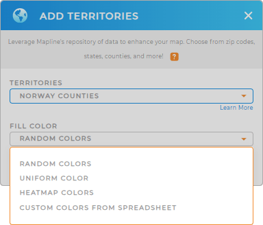
Now, add colors to your territory map to unlock powerful, location-based insights that empower you to craft business strategies. This simple yet effective strategy transforms your logistics planning, driving efficiency and profitability. Ready to optimize your business and stay ahead of the competition? Let your color-coded map lead the way!
Choose the color styling option you want to apply in your analysis, then click OK.
Now, you can sit back and start capturing insights on your map of Norway counties.

GET NEW TERRITORY INSIGHTS
Adding Norway counties to your map is just the start. You may want to add these enhanced capabilities to unlock more insights for informed decision-making:
- Automate workflows to focus on making strategic decisions
- Compare and contrast territories to find the best fit for your team
- View the geographic reach of your locations to identify underserved areas and optimize resource allocation


