
Use Paraguay Region Map for Community Planning
Mapping the Regions of Paraguay Helps Understand the Communities Better
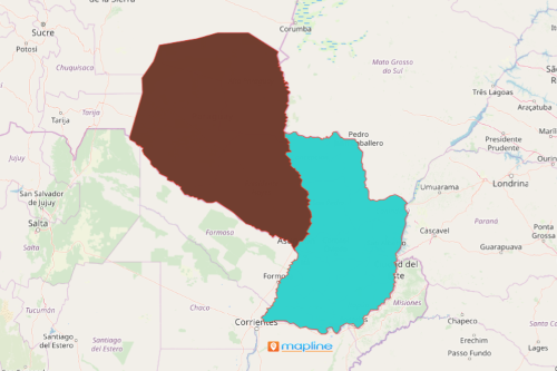
The local government authorities use a Paraguay region map to monitor each region. Paraguay is a landlocked country located in South America. The country is divided into 17 departments. These departments are divided from 2 large regions – Western (Gran Chaco) and Eastern Paraguay (Paraguay Proper). A map that shows the regions of Paraguay is used to determine the opportunities presented on each region. The insights extracted from this type of mapping is generally used in regional planning. A regional map gives a comprehensive view of what is really going on in different areas. Thus, it produces location insights that can be used in planning for community safety and security, population growth, global environment, and more.
Using mapping tools like the draw pad and segmenting address locations help to achieve data analytic goal. We all know that data analysis is not generic. Indeed, it is never a one-size-fits-all process! Hence, the draw pad gives the users the ability to draw lines and shapes to show the distance between points. Adding this tool to data analysis helps reveal connections between locations and their relationship within their regional boundary. This data analytic approach builds up informed decisions for community leaders.
How to Create a Paraguay Region Map
Map building with an overlay of Paraguay regions can be done in less than a minute. Others may be struggling for days just to come up with a map with this particular boundary. On the other hand, it takes only a few seconds to come up with a Mapline map. Then, you can start your data analysis right away!
- Create a Mapline account and login.
- Click the orange “Add New Items” button.
- Select “New Map” on the drop down arrow.
- Give your map a name and click “OK.”
- Click the “Add” button from the left sidebar.
- Select the “Territories” option.
- Click “From Mapline’s Repository.”
- From the “Territories” select “Paraguay Regions.” You can also enter that on the search bar.
- Select how you want your boundaries to be colored in “Fill Color” (Random Colors, Uniform Color, Dynamic heat map colors, or Custom colors from spreadsheet).
- Click “OK.”
Sign up now and be familiar with all the powerful mapping tools to help you with customizing your data analysis.