TOGO PREFECTURES
- Territory Guide
- TOGO PREFECTURES
Trim down your time spent in territory analysis and management as you overlay your business perspectives on a map of Togo prefectures. Many brands prefer a prefecture-level mapping for enhanced territory analysis. They offer granular insights into regional dynamics, allowing their businesses to tailor-fit their strategies to specific areas.
Got a minute? Let’s start adding this territory to your map now. Oh, did I say a minute? Try it in just a few seconds! Within a few seconds, you will have a powerful visual that lets you identify trends and patterns from data correlations.
WHAT ARE TOGO PREFECTURES?
Togo might be a small, tropical, sub-Saharan country in West Africa, but don’t let its size fool you. Each of its 35 prefectures has unique opportunities waiting to be tapped. By mapping out insights across these prefectures, you can start discovering trends and analyzing patterns, and presenting insights that will give your business that extra punch it needs to stay ahead of the competition.
Let’s say you’re in the cocoa production game. We all know that business is no walk in the park, but when you’ve got prefecture-level insights at your fingertips, you’re not just navigating blind. You’re making informed decisions, seeing through to target markets that were once hidden, and fine-tuning your routes and procedures. With this strategy, you’re not just keeping up—you’re setting the pace and driving your business toward success!
ADD TOGO PREFECTURES
Make your map of Togo prefectures your toolkit for business success! Get ready to explore trends and data context at the prefecture level to streamline your business efficiency.
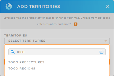
Adding a new territory from Mapline’s repository is so easy! Just type TOGO into the search bar. Then, select to add TOGO PREFECTURES from the list.
There’s just one step remaining and we’re good to go.


Pro Tip: Mapline’s comprehensive territory repository provides boundaries in Togo including Togo regions and prefectures. Get new insights as you explore other territories from different countries worldwide.
CHOOSE PREFECTURE COLORS
The last step is to incorporate colors into your territory map. Colors are an effective tool to enhance your ability to seamlessly interpret your data and make some necessary adjustments to your business strategies. Embark on the deeper analytical level as you highlight key data points or reveal trends that impact your business when you strategically apply territory colors.
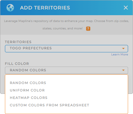
Mapline makes it easy for you to choose the right color styling depending on your type of analysis. Choose from random colors, uniform color, heat map colors, and custom colors.
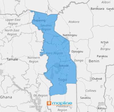
Once you have configured your color settings, click OK. Now, there’s your map of Togo prefectures ready to be used for territory analysis and management!

GET NEW TERRITORY INSIGHTS
Are you ready to unlock even more territory management solutions? Make sure to utilize these capabilities when analyzing your data on a map of Togo prefectures:
- Reduce overhead with optimized routes
- Compare competitor data with Mapline Data
- Share information with your team when you add a new dashboard


