Close
WE'RE ALL ABOUT
YOUR
SUCCESS
HOW WOULD YOU LIKE TO GET IN TOUCH:
Email
Calendar
Close
READY FOR MAPLINE TO
ROCK
YOUR WORLD?
WE WANT YOU TO EXPERIENCE EVERY-THING YOU'VE BEEN MISSING BY STARTING YOUR FREE TRIAL TODAY! OUR TEAM IS READY TO HELP CHANGE YOUR LIFE. SO REACH OUT AND WE'LL GET THINGS STARTED!
Email
Calendar
Close
READY FOR MAPLINE TO
ROCK
YOUR WORLD?
Discover the potential of Mapline with a LIVE DEMO from our experts. This is your chance to see it in real-time and get all your questions answered. Connect with us to schedule your demo today!
Email
Calendar
Close
Give us a call. We'd love to talk!

+1 800.969.1454

Close
Give us a call. We'd love to talk!

+1.888.670.3795

Close
Close
Geo Mapping Starter Close

Experience the power

Get ready to see your data in a whole new way!
Geo BI Trial Close

Experience the power

Get ready to see your data in a whole new way!
Your 7-day free trial awaits!
Geo Routing Trial Close

Experience the power

Get ready to see your data in a whole new way!
Your 7-day free trial awaits!
Geo Scheduling Trial Close

Experience the power

Get ready to see your data in a whole new way!
Your 7-day free trial awaits!
Close
Close
Find Zip Codes
in a Region with This
Mapping Trick
Find Zip Codes
in a Region with This
Mapping Trick

Trying to locate all the zip codes within a specific area can be surprisingly frustrating, especially if you’re relying on outdated lookup tools or manual spreadsheets. Whether you’re planning a sales campaign, optimizing delivery zones, or building out service territories, knowing which zip codes fall within a city, county, or radius is essential.

Luckily, with the right mapping tool, you don’t have to waste time piecing together boundaries by hand. Mapline offers a fast, intuitive way to visualize and extract zip codes for any region you’re targeting. It’s the simplest way to go from area search to actionable zip code data in just a few clicks.

Why ZIP Code Maps Beat Lists and Spreadsheets

Understanding zip code boundaries isn’t just helpful—it’s strategic. Here are some common reasons users turn to zip code maps:

  • Regional campaign planning – Target direct mail or digital campaigns more effectively.
  • Service area coverage – Define where your reps or field teams operate.
  • Market expansion research – Identify high-potential areas based on geographic reach.
  • Emergency or disaster response – Plan resource allocation by zip code.
  • Political districting or school zoning – Draw and evaluate community boundaries for specific needs.

No matter the industry, having an accurate view of your zip code coverage can drastically improve decision-making.

find zip codes within a region with mapline
magnifying glass with a checkmark inside

Pro Tip: Mapline’s free tools let you draw a radius, select a boundary, or upload a list—and instantly find zip codes in an area that match your target zone. Start for free, and scale up as your mapping needs grow.

How to Find Zip Codes in a Region Using Mapline

Manually searching for zip codes in a specific region can be time-consuming and error-prone. Mapline simplifies the process with intuitive tools that let you draw boundaries, drop pins, and instantly reveal the zip codes you need. Whether you’re planning by city, state, or a custom radius, there’s no need to sift through lists or match shapes to spreadsheets. Everything is mapped and organized visually—no GIS background required. You can even combine methods to fine-tune your coverage area and uncover new growth opportunities. Here’s how Mapline makes zip code searches fast, flexible, and frustration-free.

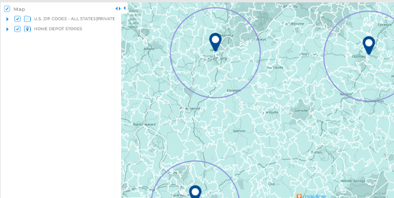
Draw a Radius to Reveal All Nearby Zip Codes

With Mapline’s radius tool, you can quickly draw a circle around any location, whether it’s 10 miles, 25 miles, or more. Once your coverage area is in place, just click ADD TERRITORY and select FROM MAPLINE’S REPOSITORY to overlay zip code boundaries. Instantly, every zip code within your radius is displayed on the map. It’s a simple, visual way to analyze regional coverage, set delivery zones, or plan field operations—no cross-referencing or manual list-building required.

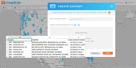
Upload a List or Start with a Single Zip Code

If you’re starting with known data, you can upload a spreadsheet of zip codes or customer addresses and instantly see how they’re distributed. This approach is ideal for refining existing territories, comparing coverage across reps, or visualizing customer clusters by zip code. You can even combine this view with radius and boundary tools for deeper insight.

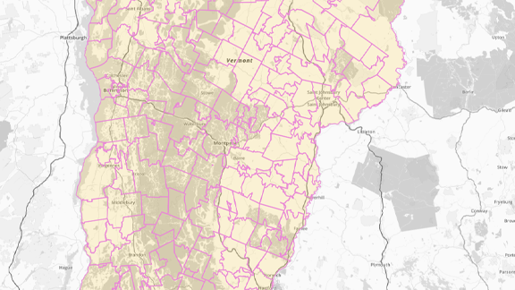
Use County or State Boundaries as a Starting Point

If you already know the general region you’re targeting, start by selecting a county or state boundary from Mapline’s territory repository. From there, you can instantly view all the zip codes that fall within that area. It’s a fast way to narrow down your focus without needing to manually search or draw anything.

Filter Zip Codes by Demographics or Performance Metrics

Need to find zip codes that meet specific criteria? With Mapline’s filters, you can layer in sales performance, population size, visit frequency, or other key data points. This lets you isolate high-potential zip codes within a region so your team can focus where it counts most.

Visualize and Customize Your Zip Code Map

Once you’ve found the zip codes you need, it’s time to bring your data to life. Mapline makes it easy to visualize zip code regions in color-coded layers that align with your business goals. Whether you’re managing sales territories, delivery zones, or customer clusters, visual customization helps teams instantly understand the data. Apply colors, filters, and labels to highlight trends, performance, or rep assignments. These interactive visuals aren’t just pretty—they’re powerful decision-making tools that make your strategy easier to execute.

Add Layers for Sales, Demographics, or Coverage

Zip code boundaries become even more useful when paired with your own data. Mapline allows you to layer in metrics like revenue, customer count, delivery volume, or visit frequency. This turns a basic boundary map into a powerful decision-making dashboard—ideal for territory planning, resource allocation, or campaign targeting.

Get instant market demographics with Mapline Data

Use Interactive Filters and Colors

With interactive filtering and color coding, your zip code map can display much more than boundaries. Highlight high-performing areas, isolate underserved zones, or adjust visuals by rep, product line, or market segment. Mapline makes it easy to build a visual strategy map that updates with your data in real time.

Segment map locations based on your data

Save and Reuse Your Zip Code Maps

Once you’ve built your zip code map, there’s no need to start from scratch each time. Any time you create a map in Mapline, it saves to your Map Library, making it easy to revisit, update, and refine your territory planning over time. You can add new layers, adjust boundaries, and view live performance metrics tied to each region.

With shared access, your team can collaborate on the same map in real time, making it a powerful asset for sales planning, field coordination, or campaign targeting. Mapline makes it easy to turn your zip code map into a living tool for smarter decision-making.

Postcode mapping software: add zip codes to your map in seconds using Mapline's repository

Plot Zip Codes on a Map Free

Say goodbye to clunky zip code lists and start using a tool that brings geographic data to life. Whether you’re managing sales territories, customer outreach, or regional strategy, Mapline helps you do it faster and more effectively. Plot zip codes on a map free and see how easy it is to find zip codes in any area.

Just getting started? You can try Mapline’s zip code tools at no cost. Plot a few zip codes, upload a test dataset, or search a boundary area using our free plan. You’ll get instant access to map visuals, zip code outlines, and radius selection. It’s the fastest way to visualize regional zip codes—no GIS expertise required.

How can I look up multiple zip codes at once?

You can easily map multiple zip codes at once by leveraging Mapline’s worldwide repository of territories. In just a few clicks, you can plot zip codes and other administrative boundaries on your map, saving time and reducing manual entry. This is especially useful for territory planning or analyzing customer clusters.

Is there a free way to map zip codes?

Yes—Mapline offers free tools to plot zip codes on a map. You can draw a radius, upload a list, or manually draw boundaries on your map. For advanced features like auto-generating a detailed boundary map or adding demographic data, consider exploring the full Geo Mapping platform.

Can I create a radius map with zip codes?

Absolutely. Just click your map layer, select COVERAGE, and enter your desired radius (e.g., 25 miles). Mapline will instantly add coverage circles to your map.

From there, you can overlay zip code boundaries using Mapline’s built-in repository, giving you a clear visual of which zip codes fall within each radius. You can even generate a detailed report listing all the zip codes inside each circle. It’s a fast, powerful way to support market analysis, delivery planning, or event targeting.

What does a zip code boundary map include?

A zip code boundary map outlines the geographic edges of each zip code area. With Mapline, you can overlay these boundaries on your business data, helping you see exactly where customers live, reps are assigned, or services are active.

Can I search for zip codes by county or state?

Yes. Use Mapline’s filtering tools or upload a list of zip codes tied to a specific state or county. You can also explore boundary layers such as county zip code maps or state zip code maps to visualize and interact with these regions.

How accurate is the zip code data?

Mapline’s data is updated regularly and sourced from reliable geographic datasets. While zip code boundaries can shift slightly over time due to USPS updates, Mapline ensures high accuracy for business mapping, logistics, and planning.

FIND ZIP CODES IN A REGION NOW