NEW ENGLAND CITY AND TOWN AREA DIVISIONS
- Territory Guide
- NEW ENGLAND CITY AND TOWN AREA DIVISIONS
Unlock a wealth of fresh insights with a map of New England city and town area divisions. More and more successful brands leverage a map using these detailed boundaries to help them manage their operations seamlessly. With a level of analysis using these area divisions, they can manage their supply chain across different states, track their sales, and plan marketing campaigns.
With deeper insights at your fingertips, you can craft strategies that hit the mark—whether you’re breaking into untapped markets, optimizing logistics for peak efficiency, or building stronger, more meaningful connections with your customers.
WHAT ARE NEW ENGLAND CITY AND TOWN AREA DIVISIONS?
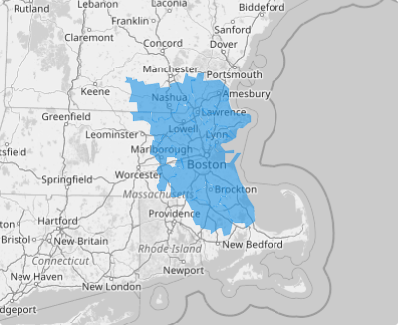
A NECTA (New England City and Town Area) with a bustling urban core of at least 2.5 million people can be further divided into NECTA Divisions, creating vibrant, localized hubs within the larger metro area. Each NECTA Division includes a central urban area and neighboring MCDs (minor civil divisions), forming dynamic communities with a combined population of 100,000 or more. The core urban area alone must host at least 50,000 residents and maintain strong internal connections, with less than 20% of its workforce commuting to other cities or towns.
These NECTA Divisions aren’t just administrative lines—they represent unique social, economic, and cultural ecosystems within the broader metropolitan tapestry. Harnessing the power of this map in mapping and data analysis gives brands a cutting-edge advantage, fueling innovation and sharpening strategies to thrive in today’s competitive landscape.
ADD NEW ENGLAND CITY AND TOWN AREA DIVISIONS
The enhanced visualization of adding territories to your map empowers better decision-making, helping you create the most effective strategies and achieve successful outcomes for your business. By providing clear, actionable insights, it enables you to make informed choices that drive growth and success.
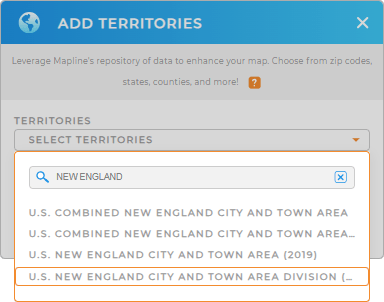
Let Mapline empower your business to reach new heights and make smarter, more impactful decisions! Just add a new territory from Mapline’s repository. In the search bar, type NEW ENGLAND and select NEW ENGLAND CITY AND TOWN AREA DIVISIONS.
Woah, that’s almost lightning speed!


Pro Tip: Mapline’s territory repository provides the latest New England city and town area divisions provided by the U.S. Census Bureau. For the latest and most accurate boundaries, just select the most recent year from the drop-down menu. This ensures you’re working with the freshest data, perfect for all your mapping and analysis needs.
CHOOSE AREA DIVISION COLORS
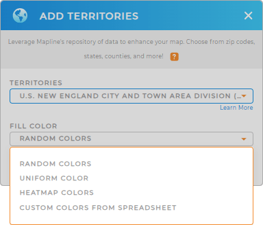
What’s next? The possibilities are endless with colors! Colors are added visual tools to enhance your map of city and town area divisions. They ignite insights to sharpen your sales analysis and market expansion. For instance, choose colors to indicate sales volume, with high sales in green and low sales in red and you have your map showing sales performance across New England! Or choose heat map colors to distinguish area divisions with the highest growth potential based on demographic data and market trends. Isn’t that awesome?
Choose from Mapline’s unprecedented color styling choices. After you’ve configured your settings, click OK.

GET NEW TERRITORY INSIGHTS
Amplify your analysis by adding these powerful capabilities to your map:
- Create engaging representation of your data and run location-based analytics
- Create an instant customer map to effortlessly see every customer’s location and status at a glance
- Add demographic data to your map to reveal more insights


