
Optimize The Usage of Gabon Map Showing Provinces
Use Route Optimization Software When Doing Province-Level Analysis
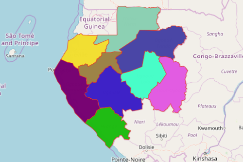
A Gabon map showing provinces is usually the go-to by organizations in the oil industry especially when there is an emerging opportunity for oil exploration. Gabon is located in Central Africa. Gabon is divided into 9 provinces: Estuaire, Haut-Ogooué, Moyen-Ogooué, Ngounié, Nyanga, Ogooué-Ivindo, Ogooué-Lolo, Ogooué-Maritime, and Woleu-Ntem. The provinces are further subdivided into 50 departments. Departments are divided into prefects and sub-prefects. Oil is the country’s predominant economy. Because of the booming market in the oil industry, most companies use maps and analysis to discover the full potential in production, situational awareness, market analysis, and business performance.
Apply Mapline’s route optimization software on a Gabon province map to find new routes and cut costs. Leverage customized routing between sources and destination for a smarter delivery process. Analyze distances between multiple stops to maximize revenues. Draw customized shapes and lines to determine how far your locations are.
Customize Your Province Map of Gabon
A few seconds more and your province map is created. Then, you can customize your territory map to build custom territory routes for drivers or employees on the road.
- Create a Mapline account and login.
- Click the orange “Add New Items” button.
- Select “New Map” on the drop down arrow.
- Give your map a name and click “OK.”
- Click the “Add” button from the left sidebar.
- Select the “Territories” option.
- Click “From Mapline’s Repository.”
- From the “Territories” select “Gabon Provinces.” Use the search bar for quicker results.
- Select how you want your boundaries to be colored in “Fill Color” (Random Colors, Uniform Color, Dynamic heat map colors, or Custom colors from spreadsheet).
- Click “OK.”
That’s how easy it is to create a Gabon map showing provinces! Once you have your map, you can create a map of Excel spreadsheet locations to overlay on top. Mapline also makes it simple to see summary information about the locations inside each province just by clicking on them! Sign up now and experience the advantage of uisng Mapline’s Routing Software.