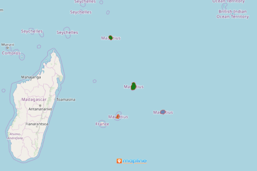
Make the Most of Your Mauritius District Map in Decision-Making
Help Attract More Investments by District Mapping
A Mauritius district map is used significantly by the export sector. Mauritius is an island country found off the southeast coast of Africa. The country includes the island of Mauritius, Rodrigues, and other outer islands. Mauritius is divided into 9 districts which are further divided into 2 cities, 4 towns and 130 villages. A district territory map with an overlay of Excel data of locations makes data and territory analyses quickly and efficiently.
With the location points carefully plotted on a district map of Mauritius, making decisions becomes less cumbersome. The map visualization captures data-based information resulting in scientific assessment thereby lessening the chance of committing errors. Mapline offers Business Intelligence training to help maximize the usage of mapping tools for decision-making. It helps the users create the best chart for location data, how to generate in-depth reports, and bring it all together on a dashboard.

Start Smart Geographic information Mapping
Once generated, your map of districts of Mauritius can be shared in just a few clicks, ensuring cross-department collaboration.
- Create a Mapline account and login.
- Click the orange “Add New Items” button.
- Select “New Map” on the drop down arrow.
- Give your map a name and click “OK.”
- Click the “Add” button from the left sidebar.
- Select the “Territories” option.
- Click “From Mapline’s Repository.”
- From the “Territories” select “Mauritius Districts.” Use the search bar for quicker results.
- Select how you want your boundaries to be colored in “Fill Color” (Random Colors, Uniform Color, Dynamic heat map colors, or Custom colors from spreadsheet).
- Click “OK.”
That’s how easy it is to create a Mauritius district map! Mapline also makes it simple to see summary information about the locations inside each district just by clicking on them! Sign up now and start using mapping tools for decision-making in a scientific manner.


