ALGERIA PROVINCES
- Territory Guide
- ALGERIA PROVINCES
Map out Algeria provinces to uncover innovative solutions and gain a competitive edge! Visualizing regional insights helps you tackle complex challenges and make smarter, more strategic decisions. This province-level analysis unlocks valuable insights into sales and marketing dynamics to guide you in your long-term business success. With this powerful tool, you can conduct laser-focused analyses, uncover hidden sales opportunities, and pinpoint marketing strategies that resonate in specific regions. Additionally, this map is perfect for conducting competitor analyses, helping you stay ahead in a targeted market.
Transform your business strategy with this in-depth, data-driven approach now!
WHAT ARE ALGERIA PROVINCES?
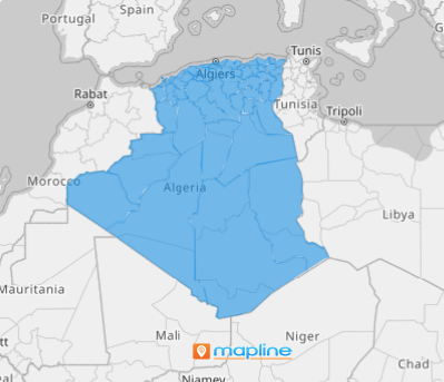
Algeria, located in North Africa, is the largest country in both the Arab world and on the African continent, and the 10th largest in the world. It’s divided into 48 provinces, making a province-level map essential for precise data interpretation.
Visualizing a map with clear province boundaries empowers sales and marketing professionals to elevate their brand promotion, manage high-performing sales teams, and fine-tune route planning. By creating a detailed territory map of the Algeria provinces, you can unlock new levels of success in customer relationship management, streamline lead generation, and optimize delivery routes.
ADD ALGERIA PROVINCES
Instantly visualize opportunities and threats in your business, enabling you to take swift, informed action in an instant. This powerful visualization tool allows you to monitor and manage your sales performance within each province with precision.
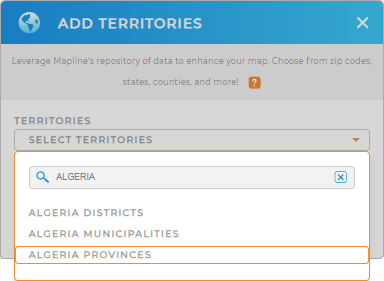
It’s so easy to add a new territory from Mapline’s repository, you’ll be done in no time! Let’s cut to the chase and add the right territory by typing ALGERIA in the search bar and select ALGERIA PROVINCES.
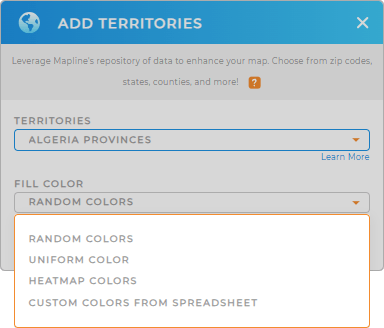
One last step to go and you’ll be done creating a province territory map with an impact.


Pro Tip: Mapline’s Repository is a must-have when you want to extract territory insights to capture global attention. Within it are hundreds of worldwide territory boundaries including Algeria provinces, Algeria districts, and Algeria municipalities that you can add to your map in a flash.
CHOOSE PROVINCE COLORS
To maximize the benefits of your province map, enhance it with the right color styles. You can use heat map colors to showcase the intensity of current activities across individual provinces or assign distinct colors to represent sales performance by province. By adding this layer of visualization, you’ll gain a clearer understanding of the regional dynamics that can drive your business forward.
When the right color styles are applied, your territory map transforms into a powerful tool that reveals valuable insights—helping you identify trends, spot high-performing areas, and uncover growth opportunities.

GET NEW TERRITORY INSIGHTS
Now, these capabilities are a must-have when analyzing your data on your map of Algeria provinces to extract more insights that can impact your decision-making:
- Quickly adjust sales team assignments with coverage areas
- Cut back in mileage with automated route planning
- Jumpstart your competitor location analysis


