BULGARIA MUNICIPALITIES
- Territory Guide
- BULGARIA MUNICIPALITIES
Creating custom maps of Bulgaria municipalities can significantly enhance your analysis for businesses. Imagine the ability to zoom in on every municipality, gaining razor-sharp insights right at your fingertips. These municipalities break down the country into a finer level of detail, allowing you to tailor your strategies with pinpoint precision. By crafting custom maps that highlight these municipalities, you’re not just enhancing your analysis—you’re revolutionizing it! This granular approach lets you address the unique needs of customers in each municipality, enabling you to develop strategies that are specific and impactful.
Let’s dive right in to set you a map of Bulgaria municipalities.
WHAT ARE BULGARIA MUNICIPALITIES?
Bulgaria is a patchwork of 265 municipalities, each one a unique blend of towns, villages, and settlements. If you want to get serious about understanding and leveraging these areas, it’s crucial to grasp the distinct characteristics of each municipality. By getting a handle on what makes each municipality tick, you can craft strategies that resonate on a local level, optimize your operations to match regional needs and uncover opportunities that might otherwise fly under the radar.
Harness detailed insights to construct business strategies that are as dynamic and effective as Bulgaria’s diverse landscape!
ADD BULGARIA MUNICIPALITIES
Add Bulgaria municipalities to your map to help you make informed decisions about where to focus business efforts. The insights gained lead to continuous business growth in market expansion, investment opportunities, and targeted marketing.
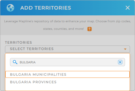
Simply add a new territory from Mapline’s repository, type BULGARIA into the search bar, and select BULGARIA MUNICIPALITIES.
We’re almost there, now let’s move on to Step 2.


Pro Tip: Add Blugaria provinces or municipalities to your map seamlessly. Leverage Mapline’s extensive list of territory boundaries to explore new opportunities and gain deeper insights to propel your business forward.
CHOOSE MUNICIPALITY COLORS
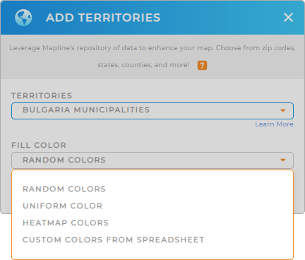
Now, let’s fill out your territory map with colors. Colors are a significant element in analysis and interpretation. A color-coded map provides a more powerful visualization that identifies trends and patterns. Imagine the moment that you finally understand your data story! Then, you can now make informed decisions and strategic plans accordingly.
To achieve that, add color styles to your territories. Fill your territories with randomized colors or uniform color. You can also apply heat map colors to visualize the intensity of a variable within each territory using a color gradient.
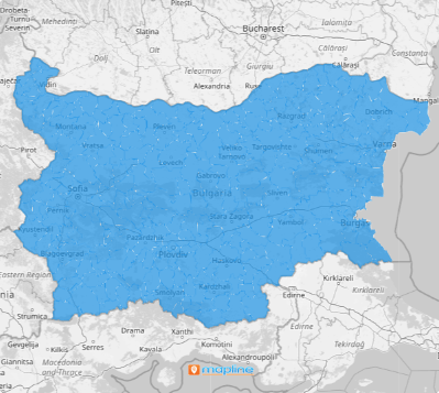
Happy with how your map of Bulgaria municipalities looks? Then click OK, and you’re all set!

GET NEW TERRITORY INSIGHTS
Now, add these capabilities to your map of Bulgaria municipalities and take your territory analysis to the next level:
- Sort your data to visualize your customers’ purchasing behavior
- Extract valuable territory insights when you view territory reports
- Identify gaps in your business with coverage areas


