
Attract New Businesses by Mapping Belgium Arrondissements
Effective Destination Branding Through Arrondissement-Level Mapping
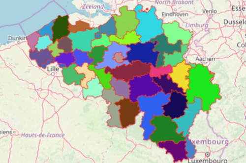
A lot of people are eager to map Belgium arrondissements. Arrondissement is a territory boundary level between provinces and municipalities. This particular boundary makes more sense to most organizations when doing data analyses. Mapline offers all 43 arrondissements of Belgium. Mapping Belgium arrondissements plays a major role in business planning, analyzing, and planning for marketing strategies. Through the powerful map visualization, you can clearly see where the growing economies are as well as the emerging markets.
Mapline provides powerful mapping tools to help economic developers with their analyses and decision-making. The spatial analysis leads to better planning, territory analysis, marketing, and community interaction.
Be Empowered Through Mapping
Follow these simple steps to create a map of Belgium arrondissements:
- Create a Mapline account and login.
- Click the orange “Add New Items” button.
- Select “New Map” on the drop down arrow.
- Give your map a name and click “OK.”
- Click the “Add” button from the left sidebar.
- Select the “Territories” option.
- Click “From Mapline’s Repository.”
- From the “Territories” select “Belgium Arrondissements.” You can also enter that on the search bar.
- Select how you want your boundaries to be colored in “Fill Color” (Random Colors, Uniform Color, Dynamic heat map colors, or Custom colors from spreadsheet).
- Click “OK.”
There are a lot more that you can do with a map of Belgium Arrondissements. Sign up now and take advantage of sharing maps or embedding maps to a website to come up with real-time access in economic strategies.