
Discover Data and Boundary Connections with a Liechtenstein Municipality Map
Mapping Municipality Boundaries Solves Location Problems
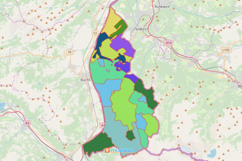
Many organizations nowadays are using a Liechtenstein municipality map. Why? Because time is of the essence, data analysis using spreadsheets and documents may not be practical. It may even be daunting and cumbersome. It can even take days. On the other hand, a territory map helps trim down the amount of time in data analysis. Indeed, when Excel data is plotted on a map, it is easily understood. However, there is another way in which organizations can truly see the connections between data and their borders. Mapline allows the users to overlay a territory boundary. Now you can add boundaries such as counties, regions, districts, and municipalities. Liechtenstein municipality is one of thousands of boundaries that can be readily overlaid on a map.
A municipality-level map helps in narrowing down possibilities. Hence, organizations can make informed decisions based on the insights gathered. There are 11 municipalities in Liechtenstein. Viewing each municipality on a map helps the users to figure out the connections of geographical locations with their borders. The more insights they gather, the more they discover patterns and connections between data and boundaries. As a result, the map shows data discovery with an impact!
Easy Mapping with Mapline
Waste no time at all as you create a Liechtenstein municipality map in seconds!
- Create a Mapline account and login.
- Click the orange “Add New Items” button.
- Select “New Map” on the drop down arrow.
- Give your map a name and click “OK.”
- Click the “Add” button from the left sidebar.
- Select the “Territories” option.
- Click “From Mapline’s Repository.”
- From the “Territories” select “Liechtenstein Municipalities.” You can also enter that on the search bar.
- Select how you want your boundaries to be colored in “Fill Color” (Random Colors, Uniform Color, Dynamic heat map colors, or Custom colors from spreadsheet).
- Click “OK.”
Be better acquainted with other mapping tools such as distance calculator to help you solve location problems. Sign up now to learn how these tools are used to discover valuable insight from your data.