
Mapping Municipalities of San Marino For Tourism
Municipality-Level Mapping to Analyze Trends and Directions in Tourism
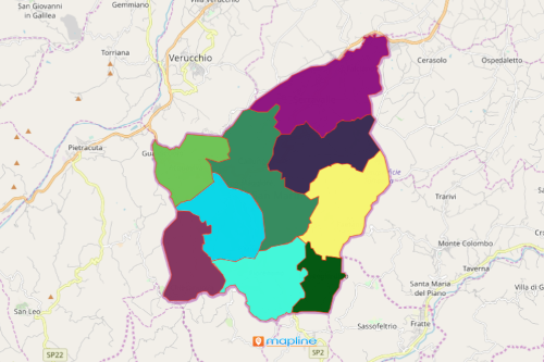
Mapping municipalities of San Marino is a must-do for organizations in the tourism industry. San Marino is a unique country. It lies within the borders of Italy. It is the 5th smallest country in the world. Its uniqueness is the reason why the country prides itself in tourism. San Marino is divided into 9 municipalities. Thus, using a map with municipal boundaries proved to be an essential tool to analyze the trends and opportunities that each municipality may bring. Furthermore, a municipality-level map helps in identifying risk factors thereby helping the users to think ahead, plan, and mitigate the risks.
Mapline develops powerful mapping tools to help organizations achieve their goals in terms of data analysis. One such tool is the territory heat map. It immediately shows a clear visual about the locations of each municipality. The heat map helps identify areas that need specific tourism demands.
The Most Advanced Solutions Starts With the Easiest Mapping
Indeed, creating a map of San Marino municipalities takes only less than a minute:
- Create a Mapline account and login.
- Click the orange “Add New Items” button.
- Select “New Map” on the drop down arrow.
- Give your map a name and click “OK.”
- Click the “Add” button from the left sidebar.
- Select the “Territories” option.
- Click “From Mapline’s Repository.”
- From the “Territories” select “San Marino Municipalities.” You can also enter that on the search bar.
- Select how you want your boundaries to be colored in “Fill Color” (Random Colors, Uniform Color, Dynamic heat map colors, or Custom colors from spreadsheet).
- Click “OK.”
Sign up now and check other mapping solutions in tourism industry. We guarantee that using mapping tools in your data analysis offers critical information that can be used to enhance productivity and increased profitability.