HUNGARY DISTRICTS
- Territory Guide
- HUNGARY DISTRICTS
Make your map of Hungary districts an analytical powerhouse! Adding district boundaries to your map is a strategic advantage that empowers you to make informed decisions and drive your business to new heights. Imagine having the powerful visuals to know exactly where your business can thrive by understanding the patterns and data. This level of analysis can transform your business operations and help you dominate the market.
Do away with guesswork! Instead, let’s add these administrative regions to your map to start reaping insights for stellar business productivity!
WHAT ARE HUNGARY DISTRICTS?
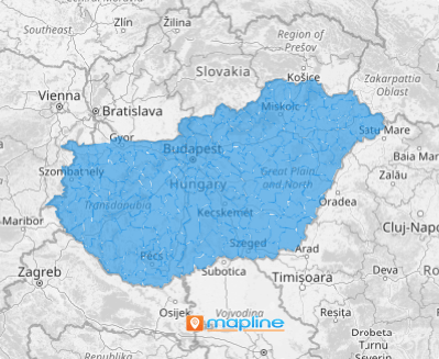
Hungary, located in Europe, is divided into 174 districts. Successful brands understand the importance of mapping these regions to gain full market insight. A district-level map of Hungary can significantly shape your business strategies and give you a competitive edge. By using district-level mapping, businesses can better analyze customer preferences and behaviors, allowing for data-driven decisions that align with customer expectations.
Add these administrative districts to your map in seconds so you can quickly visualize market trends, refine engagement strategies, and optimize their overall performance in a highly competitive environment.
ADD HUNGARY DISTRICTS
By integrating a map of Hungary districts into your analytics, you can instantly capture hidden trends across regions that may have been missed out. Enhancing your analytic capabilities with district-level insights allows you to discover regional trends that significantly aid in crafting hyper-local marketing strategies.
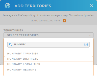
Click the ADD button on the left side of your map to add a new territory from Mapline’s repository. On the search bar, type HUNGARY and select HUNGARY DISTRICTS.
With the right territory in place, let’s go on to the last step.


Pro Tip: Gain deeper insights into your data as you add different territory boundaries to your map. Mapline’s Repository is packed with territories from different countries all over the world which includes Hungary districts, Hungary counties, Hungary regions, and Hungary localities.
CHOOSE DISTRICT COLORS
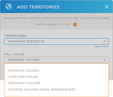
Turn complex data into crystal clear, actionable insights by applying territory color styles. Color styles are essential to highlight key factors affecting your data, making patterns and trends stand out in ways that are easily comprehensible.
Let’s bring more clarity to your data as you choose the best type of colors for your territory. Just by following this step, you elevate the visibility of insights, paving the way for more informed decision-making, allowing you to act quickly to make the necessary adjustments in your strategies.

GET NEW TERRITORY INSIGHTS
Now, these advance analytical tool are designed to give you to hone your understanding in your overall business operations:
- Segment your pins based on data
- Visualize factors influencing your business locations
- Generate a snapshot of your data when you add a report


