
Map Saint Vincent and Grenadines Parishes for Enhanced Communication
How a Map of Parishes is Used for Disaster Planning
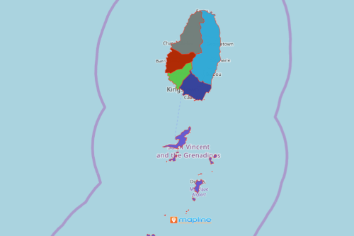
The local government agencies make it a point to always map Saint Vincent and Grenadines parishes for site selection, planning, and territory analyses. Saint Vincent and The Grenadines is a beautiful island country in the Caribbean. It is made up of 6 parishes. Due to its location in Oceania, the country is prone to natural disasters like hurricanes, coastal flooding, and tropical storms. Hence, a parish map is a big help. When parish boundaries are mapped, the pattern between locations and territories are magnified. Additionally, location data points begin to make meaning and tell stories. Therefore a territory map is crucial when planning for early warnings and information dissemination.
What’s even better is that a parish map can be easily shared to government response agencies and volunteers. In addition, the map can be embedded on a website for the whole community to look at. Mapline makes it easy to share and embed maps because we know that in the face of danger, time is of the essence. Disaster planning and communication should never be hampered. In line with that, maps can be updated in a timely manner. Mapline offers an easy edit feature wherein the users can update and edit information. This feature is essential in updating risk points. The users can add additional dataset, change the latitude and longitude of locations, delete an address, or change the distances depending on the scope of territory analyses.
From Speedy Map Cretion to a Powerful Data Visualization
Disaster planning and preparedness begins with just 10 easy steps:
- Create a Mapline account and login.
- Click the orange “Add New Items” button.
- Select “New Map” on the drop down arrow.
- Give your map a name and click “OK.”
- Click the “Add” button from the left sidebar.
- Select the “Territories” option.
- Click “From Mapline’s Repository.”
- From the “Territories” select “Saint Vincent and The Grenadines Parishes.” You can also enter that on the search bar.
- Select how you want your boundaries to be colored in “Fill Color” (Random Colors, Uniform Color, Dynamic heat map colors, or Custom colors from spreadsheet).
- Click “OK.”
Mapping your location data and territory boundaries gives you a glimpse of what lies ahead. It allows you to adjust accordingly and act quickly. Sign up now and learn more mapping tools to help enhance disaster planning.