PAKISTAN PROVINCES AND TERRITORIES
- Territory Guide
- PAKISTAN PROVINCES AND TERRITORIES
Discover the many benefits you’ll get the moment you start adding Pakistan Provinces and Territories to your map. With Mapline, you get to showcase the provinces and their respective features and opportunities that each has to offer. The platform allows you to visualize performance metrics at a granular level, making it easier to make strategic decisions and optimize resource allocation. Whether you’re assessing market saturation, uncovering growth opportunities, or refining your market approach, Mapline’s territory mapping ensures you stay informed, agile, and ahead of the competition in today’s fast-paced business environment.
Ready to see all your options? Then dive into the magic of territory management with Mapline! Let’s get you started then.
WHAT ARE PAKISTAN PROVINCES AND TERRITORIES?
Pakistan is made up of 4 provinces and 4 federal territories. The provinces are subdivided into 149 districts which are further divided into 588 sub-districts and over 5,000 local government union councils.
A deep understanding about all the provinces and territories of Pakistan is a step away into giving your organization a competitive advantage. It leads to identifying potential markets and sites for growth.
ADD PAKISTAN PROVINCES AND TERRITORIES
Suppose you’re running a business and you want to monitor your field operations. The first thing you need to do is to add the territories to your map. Provincial boundaries is a great help to visualize insights which you may miss. When you visualize the territories, you can clearly see ideas on your next bold move like allocation of resources, risks and challenges, and reaching out to potential markets.
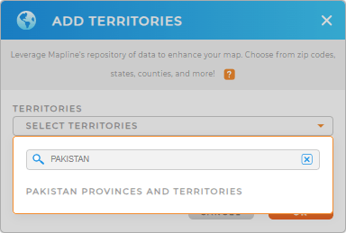
Add territories from Mapline’s Repositoty. Then type PAKISTAN in the search bar to choose PAKISTAN PROVINCES AND TERRITORIES.
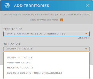
Once added, gear up for the next best thing – choosing your territory color style!


Pro Tip: Explore the versatility of Mapline’s territory repository by adding other territory boundaries of neighboring countries of Pakistan. Incorporate different territories to unlock location insights perfectly suited for your business operations.
CHOOSE PROVINCIAL AND TERRITORY COLORS
Now, you don’t want to miss this part. Applying color styles to your territories makes your map visualization so powerful that you can quickly find interrelationships between your territories and data.
Choose from the color styling options – custom-color from spreadsheet, heat map colors, random colors, and unified color. Whatever you choose, colors help you look into your map with a different eye. Understand how different factors affect the community and see opportunities that should be addressed right away.
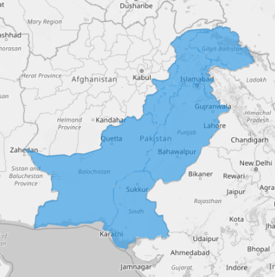
Lastly, hit OK, and you now have Pakistan provinces and territories added to your map.

GET NEW TERRITORY INSIGHTS
Are you ready to tap more in-depth insights than ever before? Then have these capabilities applied to your map of Pakistan provinces:
- Use segments to tailor marketing efforts to specific customer groups
- Watch your route efficiency skyrocket as you apply advanced route optimization
- Calculate cost-saving routes based on your customer needs with Mapline data


