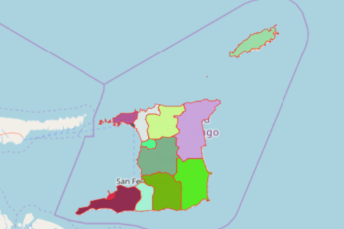
Map Municipalities and Regions of Trinidad and Tobago
Understanding Regions and Municipalities of Trinidad and Tobago
When you’re new to the beautiful archipelagic state of Trinidad and Tobago, the first thing that you consult is a map. But if you’re new to the island for business, what can really help you is not only a map but a Mapline map. Is there a difference? A lot! For example, a map of Trinidad and Tobago regions and municipalities will help you understand endless potentials when it comes to business opportunities. Because a map with overlay boundaries of regions and municipalities is a powerful visualization tool, it gives you clearer eyes to understand patterns. Hence, it will give you a heads-up on where your startup business is standing between success and failure.
To help you solve some geographic field issues and immediately resolve them, Mapline offers a boundary of 9 Trinidad Regions and 5 Municipalities. When these boundaries are overlayed on a map, you can easily uncover patterns that may prove necessary for your start-up business planning.

Create a Map of Trinidad and Tobago Regions and Municipalities
Follow these easy steps so you can create a map that is not only fantabulous but all the moreso, functional!
- Create a Mapline account and login.
- Click the orange “Add New Items” button.
- Select “New Map” on the drop down arrow.
- Give your map a name and click “OK.”
- Click the “Add” button from the left sidebar.
- Select the “Territories” option.
- Click “From Mapline’s Repository.”
- From the “Territories” select “Trinidad and Tobago Regions and Municipalities.” You can also enter that on the search bar.
- Select how you want your boundaries to be colored in “Fill Color” (Random Colors, Uniform Color, Dynamic heat map colors, or Custom colors from spreadsheet).
- Click “OK.”
Mapping Trinidad and Tobago municipalities and regions is a very helpful tool for startup planning and decision making. Sign up now and start creating amazing maps that suit your business needs.


