UGANDA DISTRICTS
- Territory Guide
- UGANDA DISTRICTS
Say goodbye to guesswork and hello to precision as you elevate your business and marketing strategies with the power of a map of Uganda districts! Unlock powerful insights hidden beneath the surface and make bold, smarter decisions that propel you ahead of the game. With district-level analysis, you can unlock the tools to connect with your target market, streamline operations, and position your business for unstoppable growth.
When you harness the insights from a district territory map, you gain pinpoint accuracy in allocating resources—deploying sales teams, positioning service providers, or optimizing logistical support to amplify your impact in the Uganda market. Let’s map these boundaries within a few seconds.
WHAT ARE UGANDA DISTRICTS?
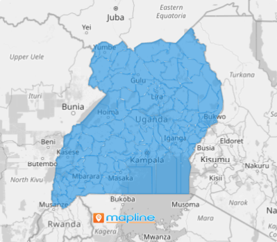
Uganda, the vibrant heart of East Africa, is a landlocked nation bursting with cultural diversity and natural beauty. As of July 1, 2020, Uganda was home to 135 districts, alongside its bustling capital, Kampala. These districts are artfully organized into four geographic regions, creating a rich tapestry of communities, landscapes, and traditions waiting to be explored!
When analyzed alongside the unique market dynamics at play, these district boundaries bring locations to life, revealing how it interacts with its borders and unlocking critical insights. But it doesn’t stop there—this approach unveils deeper layers of information, inspiring sharper strategies and more impactful decisions.
ADD UGANDA DISTRICTS
Turn perspectives into real impact—unlock powerful insights with in-depth district-level analysis to make your decisions sharper, faster, and more precise. Let your map do the heavy lifting while you focus on driving success!
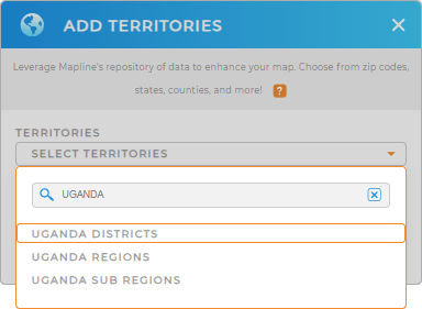
It only takes a few seconds to add a new territory from Mapline’s repository. In the search bar, type UGANDA and select UGANDA DISTRICTS.
Woah, that was so fast!


Pro Tip: Navigating the Uganda market can be overwhelming. Where should you focus your efforts? That’s where Mapline’s repository comes in. We offer detailed territory boundaries of Uganda including Uganda regions, Uganda districts, and Uganda sub-regions, giving you the tools to visualize and plan your business expansion strategically.
CHOOSE DISTRICT COLORS
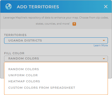
Transform your operations into a vivid story where key trends and patterns naturally stand out as you apply territory colors. Colors empower you to make smarter, more informed decisions that sharpen your logistics, streamline operations, and supercharge your marketing strategies.
Bring your data to life with strategic use of Mapline’s color styles. Whether you prefer bold, vibrant hues or subtle, harmonious tones, your chosen color scheme unveils essential location-based insights.
Lastly, hit OK.

GET NEW TERRITORY INSIGHTS
Revel these capabilities in your analysis now!
- Create custom sales territories for clearer analysis and drive smarter strategies
- Calculate anything you need from your data when you leverage Mapline Data
- Streamline your logistics with optimized routes


