Close
WE'RE ALL ABOUT
YOUR
SUCCESS
HOW WOULD YOU LIKE TO GET IN TOUCH:
Email
Email
Calendar
Cal
Close
WE'RE ALL ABOUT
YOUR
SUCCESS
HOW WOULD YOU LIKE TO GET IN TOUCH TO SCHEDULE YOUR DEMO:
Email
Email
Calendar
Cal
Mapline - mapping made powerful Close
Give us a call. We'd love to talk!

+1 800.969.1454

Close
Close
Geo Mapping Starter Close

Experience the power

Get ready to see your data in a whole new way!
Territory Guide Icon
TERRITORY GUIDE

U.S. COUNTY SUBDIVISIONS

If you’re looking for a map that can be used to organize your business presentations in small yet defined communities, a U.S. county subdivision map might be just what you need! Since county subdivision boundaries are focused on population rather than physical boundaries, you can tap directly into the needs of your potential customers.

So what are you waiting for? Here’s how to build your county subdivision map now.

WHAT ARE U.S. COUNTY SUBDIVISIONS?

U.S. County Subdivisions are administrative divisions within counties, providing a more detailed breakdown of geographic areas for businesses operating at a local level.

For instance, a delivery service company could leverage U.S. County Subdivisions to optimize route planning by precisely mapping out neighborhoods or towns within a county. This granularity allows businesses to tailor their marketing campaigns to specific local demographics, target areas with high demand, and allocate resources more efficiently based on localized customer needs.

By adding U.S. County Subdivisions to their Mapline maps, business owners can gain invaluable insights into local markets, streamline operations, and ultimately enhance customer satisfaction.

ADD SUBDIVISIONS

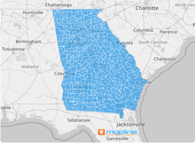
It only takes a few seconds to add county subdivision boundaries to your map. It’s just one of the many ways Mapline makes it easier to get exacly what you need.

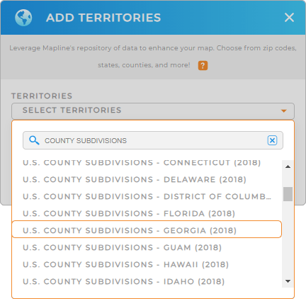
First, add a new territory from Mapline’s repository, then type COUNTY SUBDIVISIONS into the search bar.

It couldn’t be any easier, unless we handed you a magic want. (Don’t worry, we’ll invent this one day).

Choosing to add U.S. County Subdivisions
magnifying glass with a checkmark inside

Pro Tip: Mapline provides the latest County Subdivision boundaries available from the U.S. Census Bureau. Select the most recent year to get the most up-to-date boundaries.

ADD SUBDIVISION COLORS

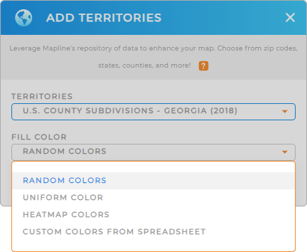
Now, let’s take your territories to the next level! Color-coded territories enhance the functionality and aesthetic of your map, helping you drill down into important insights.

Just select the type of color styling that best fits your needs, then click OK.

Waoh, that was fast!

Color Style for U.S. County Subdivisions

GET NEW TERRITORY INSIGHTS

Here are the top ways to maximize the use of your US county subdivision map:

Map of U.S. County Subdivisions
Have questions? Want to see this in action?