How-To Guide
Add or Edit Map Territories
- How-To Guide
- Add or Edit Map Territories
Adding territories to your map empowers you to define and visualize specific geographic areas, making it easier to analyze data within those boundaries.
Whether you’re marking sales regions, service areas, or any other segmented space, this is a simple, effective way to uncover insights you never knew existed.
ADD TERRITORIES
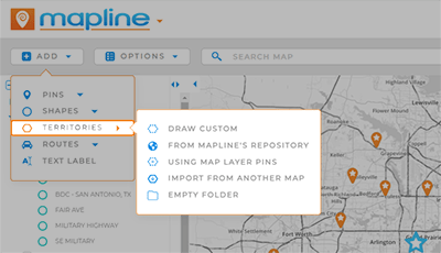
From the ADD menu, hover over TERRITORIES and select the type of territory you need.
Draw Custom: This option enables you to draw custom territory shapes directly on your map, tailored to your specific requirements.
From Mapline’s Repository: Tap into Mapline’s proprietary territory data to add predefined boundaries like zip codes, county lines, state boundaries, and more to your map.
Using Map Layer Pins: Effortlessly generate new territories from your existing map pins.
Import from Another Map: Pull territories from your existing maps in Mapline, ensuring consistency across the board.
Empty Folder: Create an empty territory folder in your map sidebar, which you can later populate with the territories you need.

EDIT OR DELETE TERRITORIES
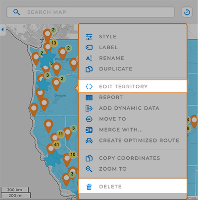
Right-click an individual territory or a territory Layer Folder to access a variety of customizations.
Edit: Are your borders off? Need to change your territory shape? Revise your territory borders by dragging the corners of your shape into place.
Style: Customize the appearance of your territories.
Label: Add custom labels to your map.
Rename: Revise the name of a territory or territories.
Add Data: Leverage Mapline Data to enhance your territory insights even further.
Report: Access the Folder Report for your territory. Alternatively, left-click a territory to view a quick snapshot of your data.
Merge With: Pre-defined government boundaries sometimes cause territory holes. Merge bordering territories to blend areas and eliminate holes.
Create Optimized Route: Auto-calculate the most efficient route(s) for the pins within a territory.
Add Shapes: Segment territory data even further with custom shapes.
Settings: Configure your layer settings to customize the appearance and behavior for your territory Layer Folder.


