U.S. SCHOOL DISTRICTS
- Territory Guide
- U.S. SCHOOL DISTRICTS
In the ever-evolving landscape of business analytics, one key aspect often overlooked is the impact of local educational systems. Imagine having the ability to precisely map out elementary, secondary, and unified school districts in seconds, gaining valuable insights that could revolutionize your approach.
With Mapline, it’s not just a possibility – it’s a few clicks away! Let’s explore how adding U.S. school districts to your map can open new avenues for understanding, strategizing, and enhancing your business operations.
Let’s dive in!
WHAT ARE U.S. SCHOOL DISTRICTS?
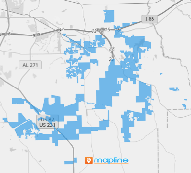
A U.S. school district map delineates the geographical boundaries of educational districts across the country, providing a visual representation of where schools are located and which areas they serve. These maps can provide invaluable insights for businesses.
For example, it’s crucial for property developers and investors to understand school district boundaries when assessing property values and market demand.
By leveraging a school district map, businesses can make informed decisions about where to invest in residential or commercial properties, taking into account the quality of local schools and the potential impact on property values. Whether you’re a real estate professional or a community planner, school district maps offer valuable insights into local education landscapes, helping you navigate opportunities and make strategic decisions with confidence.
ADD U.S. SCHOOL DISTRICTS
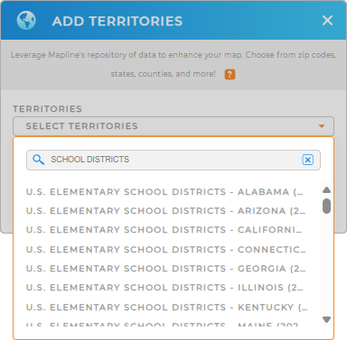
First, add a new territory from Mapline’s Repository. Then, utilize the search bar to find the school district you’d like to add. It may be:
- ELEMENTARY: A district for grades K-5/6 providing primary education.
- SECONDARY: A district for grades 6/7-12 delivering middle and high school education.
- UNIFIED: A district combining K-12 education in a single administrative structure.
This is a great way to get a nuanced understanding of demographics, program variations, and comprehensive K-12 landscapes for targeted planning.


Pro Tip: Mapline’s Repository ensures you have the latest school district boundaries available from the U.S. Census Bureau. Stay current by selecting the most recent year from the drop-down menu.
CHOOSE DISTRICT COLORS
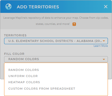
Next, set your territories apart with custom coloring! Custom territory colors give you easy visual distinction and categorization of districts, helping you swiftly identify crucial factors that impact operations and enhance strategic decision-making.
Choose the right territory color styles and you’re map is good to go.

GET NEW TERRITORY INSIGHTS
But it doesn’t stop there! Now that you have a U.S. school district map, you can leverage it to:
- Identify opportunities within each school district by adding US Demographics
- Compare and contrast public school system programs in elementary, secondary, and unified school districts
- Initiate programs and activities to target the specific needs of students by creating coverage areas


