
Create a Dynamic Region Map of Cameroon
A Few Clicks is All It Takes to Build a Dynamic Map
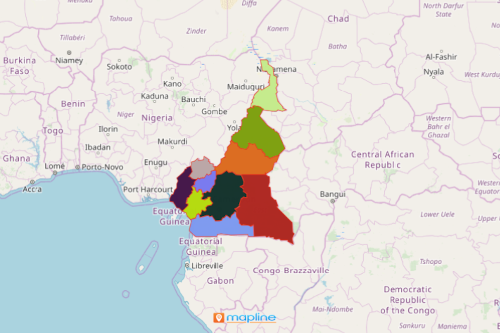
A region map of Cameroon can give you a powerful visualization that provides more than just territory boundaries. By applying several mapping tools, you can turn it into a dynamic map! Cameroon is a West African country divided into 10 semi-autonomous regions. These regions are further divided into 58 divisions. The divisions are subdivided into sub-divisions (arrondissements). Each region is headed by a governor appointed by the president of the country.
With Mapline, your Cameroon region map becomes even more dynamic. How? You have the option to embed the maps into your websites. Your map can also be shared internally or shared directly with others. Now here’s a new feature. You can now use query strings to automatically search for specific locations. With the query string, you can also draw a coverage circle.
A More Powerful Map of Cameroon
Create a dynamic map that populate data for your users.
- Create a Mapline account and login.
- Click the orange “Add New Items” button.
- Select “New Map” on the drop down arrow.
- Give your map a name and click “OK.”
- Click the “Add” button from the left sidebar.
- Select the “Territories” option.
- Click “From Mapline’s Repository.”
- From the “Territories” select “Cameroon Regions.” Use the search bar for quicker results.
- Select how you want your boundaries to be colored in “Fill Color” (Random Colors, Uniform Color, Dynamic heat map colors, or Custom colors from spreadsheet).
- Click “OK.”
That’s how easy it is to create a region map of Cameroon! Once you have your map, you can create a map of Excel spreadsheet locations to overlay on top. Mapline also makes it simple to see summary information about the locations inside each region just by clicking on them! Sign up now to start creating dynamic maps!