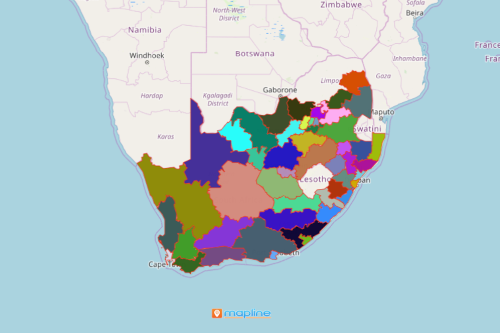
How a South African Map Showing Districts is Used in Fleet Industry
Reap the Benefits of Mapping District Boundaries
A South African map showing districts is extremely useful for organizations in the fleet industry. South Africa is divided into 9 provinces and further divided into 52 districts – the metropolitan (8 districts) and municipalities (44 districts). A district map with an overlay of different segments of Excel data brings out key insights that are useful in planning, operations, sales, and marketing. Mapping South Africa districts is the first step to give organizations a clear direction in running their business. It provides a powerful visualization of how a company’s design and system of the fuel management process works.
Not only can companies add data into territory boundaries. Mapline Solution Suite is a business data framework that allows organizations to provide their customers’ timely data. They can also analyze their current delivery locations, create and evaluate bulk routes, and ensure maximum efficiency.

Mapping South African Districts Made Easy
Here are the steps:
- Create a Mapline account and login.
- Click the orange “Add New Items” button.
- Select “New Map” on the drop down arrow.
- Give your map a name and click “OK.”
- Click the “Add” button from the left sidebar.
- Select the “Territories” option.
- Click “From Mapline’s Repository.”
- From the “Territories” select “South Africa Districts.” Use the search barfor quicker results.
- Select how you want your boundaries to be colored in “Fill Color” (Random Colors, Uniform Color, Dynamic heat map colors, or Custom colors from spreadsheet).
- Click “OK.”
That’s how easy it is to create a South African map showing districts! Mapline also makes it simple to see summary information about the locations inside each district just by clicking on them! Sign up now and see for yourself all the benefits of using the Mapline Solution Suite.


