
How to Create a Zambia Map
Previously known as Northern Rhodesia, the Republic of Zambia is a country located in Southern Africa. Its neighboring countries are Democratic Republic of the Congo, Malawi, Mozambique and Tanzania. Zambia is home to the world-renowned Victoria Falls.
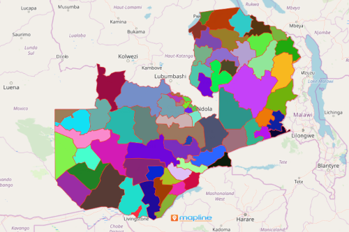
Using Mapline, you can easily create a map of Zambia districts. Zambia is divided into 10 regions or provinces as its first administrative division. These are further divided into 103 districts, 150 constituencies and 1,430 wards. Districts in Zambia are organized to help build strategic programs that may result in poverty reduction, effective uses of scarce resources, and population risk management. When you create a map of Zambia districts, you can easily assess the region by demographics, population, and sales and marketing potential.
Steps to Create a Map of Zambia Districts
- Create a Mapline account and login.
- Click the orange “Add New Items” button.
- Select “New Map” on the drop down arrow.
- Give your map a name and click “OK.”
- Click the “Add” button from the left sidebar.
- Select the “Territories” option.
- Click “From Mapline’s Repository.”
- Search for “Zambia Districts” or enter “Zambia Districts” on the search bar.
- Select how you want your boundaries to be colored in “Fill Color” (Random Colors, Uniform Color, Dynamic heat map colors, or Custom colors from spreadsheet).
- Click “OK.”
That’s how easy it is to create a map of Zambia districts! Ready to create your first Mapline map? Find information about our individual, team, API and custom plans to get started today.
Explore Other Mapping Features
Want to know what else you can do with your Zambia district map? Check out our other features: