
Create a Bangladesh Map Showing Divisions Fast!
Division Boundary Mapping For In-Depth Territory Analysis
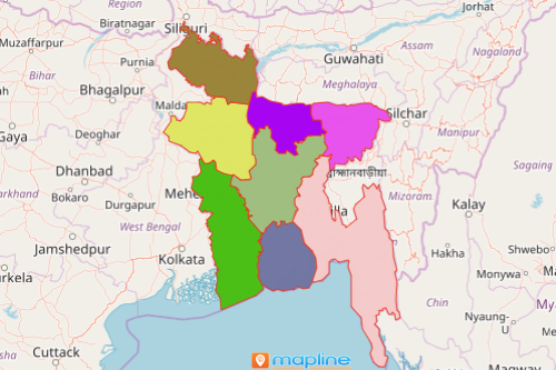
A Bangladesh map showing divisions is something that many business companies rely on for site analysis and territory planning. Bangladesh is divided into 8 divisions. Because of the country’s growth-leading economies, no wonder that more and more companies in different sectors choose to invest there. A Bangladesh division map is a handy tool to help them choose the best locations for their business.
One of the most sought after mapping tools that business organizations use to help with market research and territory analyses is heat map. Heat maps produce color-coded concentrations to show the difference between densely populated areas versus the least populated areas. These color-coded concentrations help to discover the markets most likely to yield success.
How to Create a Map of Bangladesh Showing Divisions
Map creation in Mapline is made simple and fast so that you can spend most of your time in territory analyses.
- Create a Mapline account and login.
- Click the orange “Add New Items” button.
- Select “New Map” on the drop down arrow.
- Give your map a name and click “OK.”
- Click the “Add” button from the left sidebar.
- Select the “Territories” option.
- Click “From Mapline’s Repository.”
- From the “Territories” select “Bangladesh Divisions.” Use the search bar for quicker results.
- Select how you want your boundaries to be colored in “Fill Color” (Random Colors, Uniform Color, or Custom Colors From Spreadsheet).
- Click “OK.”
That’s how easy it is to create a Bangladesh map showing divisions. Once you have your map, you can create a map of Excel spreadsheet locations to overlay on top. Then, get summary information about the locations inside each division just by clicking on them. Learn more about our individual, team, API and custom plans to get started today.