AUSTRALIA LOCAL GOVERNMENT AREAS
- Territory Guide
- AUSTRALIA LOCAL GOVERNMENT AREAS
Unleash the full potential of your analytics with a map of Australia Local Government Areas! By adding these areas to your map, you’ll be tapping into local perspectives and gaining new insights that drastically improve your business!
Stay ahead of the curve with a sharp, region-focused approach—because every move matters! Dive into detailed regional analysis and boost your business performance by mapping out these local government areas. Here’s how.
WHAT ARE AUSTRALIA LOCAL GOVERNMENT AREAS (LGAs)?
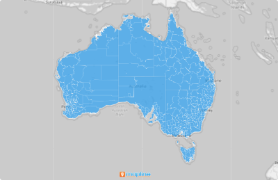
Australia Local Government Areas (LGAs) are the administrative divisions within the states and territories of Australia. Each LGA encompasses several neighborhoods or communities, serving as a crucial unit for regional governance and planning. Leveraging a map of these LGAs can help businesses in sales, marketing, logistics, and operations to strategically plan and execute their initiatives. Mapping these territories provides clarity and precision, ensuring that your business efforts are directed towards the most impactful areas.
ADD LGAs TO MAP
Integrating Australia Local Government Areas into your Mapline map opens up a world of possibilities for detailed data analysis. By building a detailed territory map, you’re giving your organization the ultimate advantage for unstoppable growth.
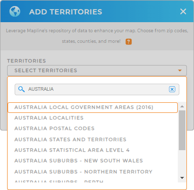
First, add a new territory from Mapline’s Repository, and type AUSTRALIA into the searchbar. Select AUSTRALIA LOCAL GOVERNMENT AREAS from the drop-down.
With access to this vast repository, you can add various regions to your map, unlocking key business opportunities for your business.


Pro Tip: Mapline’s extensive list of territory boundaries is a game-changer. Explore other territories in Australia, such as Australia localities, Australia postal codes, Australia states and territories, Australia suburbs, and Australia statistical areas. Unlock fresh opportunities and make smarter decisions by tapping into the power of Australia’s boundaries—your key to sharper insights and strategic success.
CHOOSE LGA COLORS
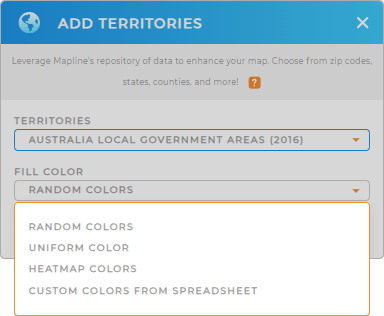
Cool, right? Now we’re getting on to the more exciting part – color-coding your map. Colors make your map visualizations so impactful that you’ll quickly gain new insights about local markets, potential customers, and how to get the most bang for your buck.
Just choose your desired color styling to make critical data points stand out and streamline your decision-making process. When you’re done, click OK.

GET NEW TERRITORY INSIGHTS
With your new map in tow, you can:
- Create efficient routes that optimize themselves
- Analyze your coverage areas and improve market penetration
- Take your visualization and analysis up a notch by adding additional data


