Close
WE'RE ALL ABOUT
YOUR
SUCCESS
HOW WOULD YOU LIKE TO GET IN TOUCH:
Email
Email
Calendar
Cal
Close
WE'RE ALL ABOUT
YOUR
SUCCESS
HOW WOULD YOU LIKE TO GET IN TOUCH TO SCHEDULE YOUR DEMO:
Email
Email
Calendar
Cal
Mapline - mapping made powerful Close
Give us a call. We'd love to talk!

+1 800.969.1454

Close
Close
Geo Mapping Starter Close

Experience the power

Get ready to see your data in a whole new way!
Territory Guide Icon
TERRITORY GUIDE

U.S. AREA CODES

U.S. area codes can unveil vital, location-relevant information. It’s the perfect way to get a high-level overview of vital points of interests, allowing you to visualize entire cities, sections of cities, or whole states.

Whether you’re looking for population insights, household data, or you need to optimize your sales territories by location, you’re in the right place.

So why not dive in and see what’s possible for your brand? Fasten your seatbelt–we’re about to take you down the fast-track to adding U.S. area code boundaries to your map.

WHAT ARE U.S. AREA CODES?

U.S. Area Codes are geographic regions within the United States, each assigned with a unique three-digit code. These codes are used in phone numbers to designate specific geographic areas where callers reside.

These regions can be useful to brands, particularly those that collect phone data from customers. For example, a brand could leverage a map of U.S. area codes to identify regions with a high denisty of customers. By overlaying customer data onto the map, it becomes easy to pinpoint opportunities and run targeted marketing campaigns, promotions, and product offerings for those areas.

ADD U.S. AREA CODES

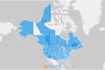
Transform the way you understand and optimize your business strategies with the power of U.S. area code mapping!

In just moments, you can visualize the geographic distribution of area codes and tap into key regional data.

Let’s say a retail business wants to to identify high-density areas for targeted marketing. The power to visualize this information is right at your fingertips – just add a new territory like usual, then type AREA CODES in the search bar.

BAM! That was easy!

Choosing US Area Codes territory
magnifying glass with a checkmark inside

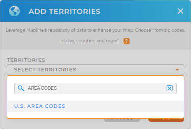
Pro Tip: Mapline provides the latest area code boundaries available from the U.S. Census Bureau. Select the most recent year from the drop-down to get the most recent boundaries.

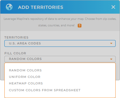
CHOOSE AREA CODE COLORS

Now, we’re just warming up.

You have total control of your map’s appearance. Custom colors give you the power to see any data you choose in a glance, whether you want static colors or dynamic styling that’s tied directly to your data.

Maybe you want high-density area codes in red, or you want to highlight which percentage of your existing customer base has which area codes.

Just choose your preferred color style and click OK. Next, make sure your dataset contains the information you want to see on the map, and you’re all set!

Color Styles for US Area Codes

GET NEW TERRITORY INSIGHTS

Now that your map displays the most recent U.S. area codes, let’s check out some powerful ways brands leverage these territories in Mapline:

Map of US Area Codes
Have questions? Want to see this in action?