Go to Mapline to Create a Cote d’Ivoire Map Showing Regions
Region-Level Planning Helps to Implement Community Programs
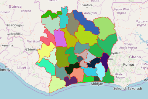
Why do a growing number of organizations need to use a Cote d’Ivoire map showing regions? Known also as the Ivory Coast, the country is located in West Africa. Cote d’Ivoire is divided into 31 regions. Regions are further divided into 2 or more smaller subdivisions. The regional boundaries are responsible for planning and implementing programs to improve the cultural, economic, and social life of each region. They are also responsible for coordinating the activities of their departmental governments while implementing the projects of the national government.
In Mapline, a region map of Cote d’Ivoire does not only show territorial boundaries. Come map with us and get a first hand experience of how real territory and data analysis work! You get access to heat mapping, improved territory reports, overhauled segmenting, pin customization, public map sharing, “zoom to” options, and many more!
Easy Steps to Create a Map
If you start now, you can finish creating your Cote d’Ivoire regions map in just a few seconds. Then you can start your analysis right away!
- Create a Mapline account and login.
- Click the orange “Add New Items” button.
- Select “New Map” on the drop down arrow.
- Give your map a name and click “OK.”
- Click the “Add” button from the left sidebar.
- Select the “Territories” option.
- Click “From Mapline’s Repository.”
- From the “Territories” select “Côte d’Ivoire Régions.” You can use the search bar to search for the name of the territory.
- Select how you want your boundaries to be colored in “Fill Color” (Random Colors, Uniform Color, Dynamic heat map colors, or Custom colors from spreadsheet).
- Click “OK.”
That’s how easy it is to create a Cote d’Ivoire map showing regions! Once you have your map, you can create a map of Excel spreadsheet locations to overlay on top. Sign up now!