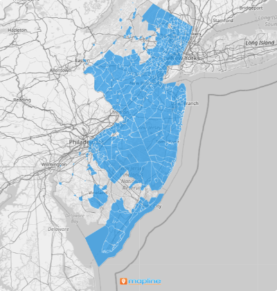
Close
WE'RE ALL ABOUT
YOUR
SUCCESS
HOW WOULD YOU LIKE TO GET IN TOUCH:
Email
Email
Calendar
Cal
Close
WE'RE ALL ABOUT
YOUR
SUCCESS
HOW WOULD YOU LIKE TO GET IN TOUCH TO SCHEDULE YOUR DEMO:
Email
Email
Calendar
Cal
Mapline - mapping made powerful Close
Give us a call. We'd love to talk!

+1 800.969.1454

Close
Close
Geo Mapping Starter Close

Experience the power

Get ready to see your data in a whole new way!
Territory Guide Icon
TERRITORY GUIDE

U.S. MUNICIPALITES

If you’re looking for business insights that set your brand apart, you may want to create a map of U.S. municipalities instead of a county or state map. That way, your data insights will be more focused on details that may bring more impact. Municipality territories include cities, boroughs, and townships.

Why not go ahead and create your U.S. municipality map now?

WHAT ARE U.S. MUNICIPALITIES?

A U.S. municipality map offers local authorities a comprehensive view of incorporated settlements, such as cities, boroughs, villages, and towns. For businesses, especially healthcare providers, these maps serve as vital tools for optimizing service delivery.

For instance, healthcare organizations can leverage municipality maps to identify areas with high healthcare needs, allowing them to allocate resources efficiently and respond promptly to medical emergencies. Similarly, first responders benefit from municipality boundary maps by gaining situational awareness during crises, enabling them to make informed decisions and take swift action to ensure public safety.

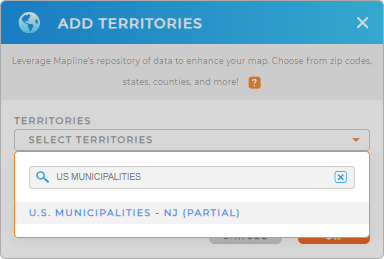
ADD U.S. MUNICIPALITIES

Spot trends, identify pattens, and manage sales territories when you create a municipality map.

First, add a new territory to your map, then type U.S. MUNICIPALITIES in the search bar. Select the area you need, and you’re all set.

Step one, done!

Adding US Municipalities in New Jersey

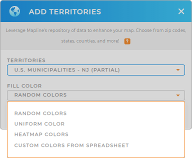
CHOOSE MUNICIPALITY COLORS

This is the fun part–you get to make your map awesome! Custom territory colors empower you to create a visual overview of your data.

Maybe you’re looking to create a targeted marketing campaign for specific municipalities? Use static colors for precise demographic analytics, or heat map colors for an overview of consumer behavior.

Or perhaps you’re looking to optmize your supply chain within certain areas? Use automated colors to style your territories based on your data. Whenever your data changes, the map will update, too.

How incredible is that?

Color Styles for US Municipalities

GET NEW TERRITORY INSIGHTS

Start your data analysis by digging in to segments of townships, boroughs, or cities. Here are some useful ways brands leverage a U.S. municipality map:

Map of US Municipalities in New Jersey
Have questions? Want to see this in action?