Close
WE'RE ALL ABOUT
YOUR
SUCCESS
HOW WOULD YOU LIKE TO GET IN TOUCH:
Email
Email
Calendar
Cal
Close
WE'RE ALL ABOUT
YOUR
SUCCESS
HOW WOULD YOU LIKE TO GET IN TOUCH TO SCHEDULE YOUR DEMO:
Email
Email
Calendar
Cal
Mapline - mapping made powerful Close
Give us a call. We'd love to talk!

+1 800.969.1454

Close
Close
Geo Mapping Starter Close

Experience the power

Get ready to see your data in a whole new way!

Author: Mapline Team

3 Ways to Use GIS Mapping in Higher Education

GIS mapping is a powerful technology, and many college and university professors are taking note of its utility as a classroom learning tool. While its uses vary across majors and degree concentrations, GIS provides all students with a range of skillsets, such as problem solving and database management, as well as map creation, data accuracy, and the ability to adapt to technology in ever-changing workforces. How does this translate for students in the classroom? Here are three real-world examples of how college professors use GIS technology.

1. Honing Skills for Further Research

Professors at Dickinson College pair GIS with academics to teach students to think about problems in a spatial context. They encourage students to ask:

Mapline’s Mock Election Platform Helps Students Cast Their Ballots

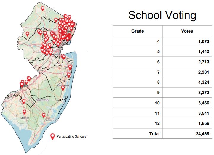
At Mapline, we’ve collaborated with New Jersey teachers and schools to help students vote in elections and experience the democratic process. Our interactive mapping software for schools makes it easy for teachers to register their students’ participation and analyze the results once all votes have been counted. For most students, the New Jersey mock election is the first opportunity they’ll have to cast a vote.

YourNews Leverages Mapping Software to Publish Nationwide Local News Online

Daily news platform YourNews brings local news online to audiences across the United States. By partnering with network affiliates and advertisers, the company serves a nationwide audience by Zip Code. The website—an aggregate of city, county, state, regional and international news stories—aims to provide accessible local news to as many readers as possible amid declining print newspaper readership. To achieve his goal, Sam Anthony, CEO and president of YourNews, needed to find affiliates to help serve news, as well as advertisers to promote it. When a colleague recommended he try a geographic network map, Anthony questioned the idea. Did he need to plot points on a map? How would creating a network map pay off for his business in the end?

3 Benefits of Route Planning Software

Planning routes by hand has never been an easy task. Whether your priority is managing a successful sales team or scheduling a large fleet, manual planning can lead to route inaccuracies. And inaccuracies mean unhappy customers, decreased lead generation, and costly delivery blunders. The solution? Powerful automated route planning not only creates efficient routes in just minutes but also helps identify your best opportunities for growth. Check out three ways route planning software leads to business success.

Route Planning Leads to Increased Sales

Your sales reps’ wish list likely includes faster routes and shorter drive times. With route planning, simply draw a custom shape around a sales territory. Then, the mapping application creates a personalized route with pins, based on start and end points. Route planning software allows sales reps to visualize their daily schedule on a map, decrease drive time, and ultimately add more appointments to their calendar. And when your reps have more time to spend in their territory, they sell faster and smarter.

How 3PL Companies Use Geospatial Data

In today’s global society, one product may travel by rail, ship, plane and truck to reach its destination. While globalization creates a more connected world, it also introduces complexities to supply chains. Supply chain managers must orchestrate multiple facilities, and they are responsible for countless interactions and dependencies. As a result, many rely on third party logistics companies for warehousing, monitoring, tracking, and tracing. Most 3PL providers use GPS and GIS systems for a real-time look into monitoring and managing supply chain deliveries. So, how does this impact operations for decision-makers? Here are a few ways 3PL companies leverage geographic insights through GIS logistics.

GIS: A Modern Tool for Modern Problems

For most supply chains and 3PL providers, geographic data is a tool that underlies all strategic decisions. At its core, a GIS tool is designed to store geographic data for further analysis, reporting, graphing and insight. It supplies a convenient way to manage spatial information visually—and uncover patterns or trends within data. Third party logistics companies use advanced GIS systems to achieve several goals for their supply chain clients, including:
  • Assisting with fleet management
  • Improving transportation communication
  • Tracking vehicle locations
  • Monitoring vehicle performance (e.g. condition of tires, fuel level)
  • Checking routes for driver safety
  • Monitoring inventory levels and shipping times
  • Optimizing on-hand supply levels
Companies that choose to ignore location-based data, or don’t use a 3PL who employs real-time GIS logistics, are risking big consequences. Inventory may go to waste, arrive late or not at all. Weather may cause delays, and without essential monitoring and tracking in place, supervisors can’t swiftly advise drivers on alternate routes. Without GIS logistics driving location-based analyses and decisions, 3PLs struggle to plan schedules and forecast costs.

Skillsets for Successful GIS Execution

It’s true—the right GIS technology helps 3PL professionals analyze the impact of location, weather and natural disasters near distribution hubs, departure and arrival times, and much more. However, efficient use of a geospatial data system requires in-depth knowledge in a variety of areas. To ensure your 3PL business is making the most of your current system or is well-equipped to adopt a new GIS mapping software, it’s important to assess employee readiness. Third party logistics employees can be trained in key fields to make the best use of a GIS system, such as:
  • Computer programming
  • Cartography
  • Visual design
  • System administration
  • Database management
By using a GIS system to its full potential, decision-makers can manage large datasets and achieve a holistic view that can improve activity and production across nearly every point in the supply chain. Are you interested in GIS mapping for your business? Learn more about GIS mapping and spatial analysis for supply chain management now.

The Importance of Adopting GIS for Education

Businesses worldwide recognize the usefulness of geography. Geography has applications in many professions, such as business, marketing, criminal justice, public administration and social work. Increasingly, companies want employees with experience in GIS technology. Job candidates can stand out by learning GIS concepts and obtaining valuable geographic skills in college alongside core classes like math and English. However, sometimes students and faculty members in business school, for example, feel too removed from geography and may misunderstand the value science can have when applied to business concepts. Professors who welcome spatial science into their curricula acknowledge the powerful way geography supports decision-making in the business world—and they impart critical, experiential opportunities on their students.

What Is GIS Used for in College?

With GIS, students learn to be strategic and connect spatial strategies to business principles. Creating maps that show audience demographics, practicing research and analysis, and delving into business information and spatial logistics—these are all essential GIS elements that, when applied in the higher education classroom and carried into a career, help students become strong decision-makers, analyzers, entrepreneurs and leaders.